By: Charlotte Milne
At a glance
THE SITUATION
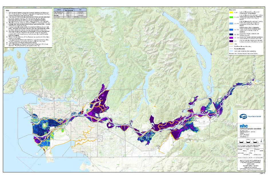
Many flood risk reduction decisions are made based on flood maps that show where flood waters are likely to go, how dangerous the water might be, and who/what might be damaged in different flood scenarios. Flood mapping is currently increasing across “Canada” and “B.C.” as communities seek to manage ever more frequent and severe flood hazards.
THE PROBLEM
Flood maps have historically been grounded in western scientific knowledge alone. While the contributions of western science are essential for our understanding of floods, Indigenous Peoples also hold a wealth of expertise having witnessed changes in water behaviour since time immemorial. However, until very recently, First Nations peoples in Canada have rarely been given the opportunity to have meaningful input into flood map creation.
The omission of First Nation knowledge systems and priorities from flood mapping is problematic as flood maps can directly influence everything from which communities receive climate adaptation funds, to what assets should be prioritized for flood protection. The exclusion of First Nations from flood management in B.C. has additionally contributed to the repetitive flood damages many Nations now face, and the over-selection of flood management methods that have led to environmental degradation in their territories.
While there has been a rise in engagement and funding for First Nations to undertake flood mapping, often this is only within their reserve land boundaries, despite flood management having implications at watershed or territory-wide scales.
THE SOLUTION
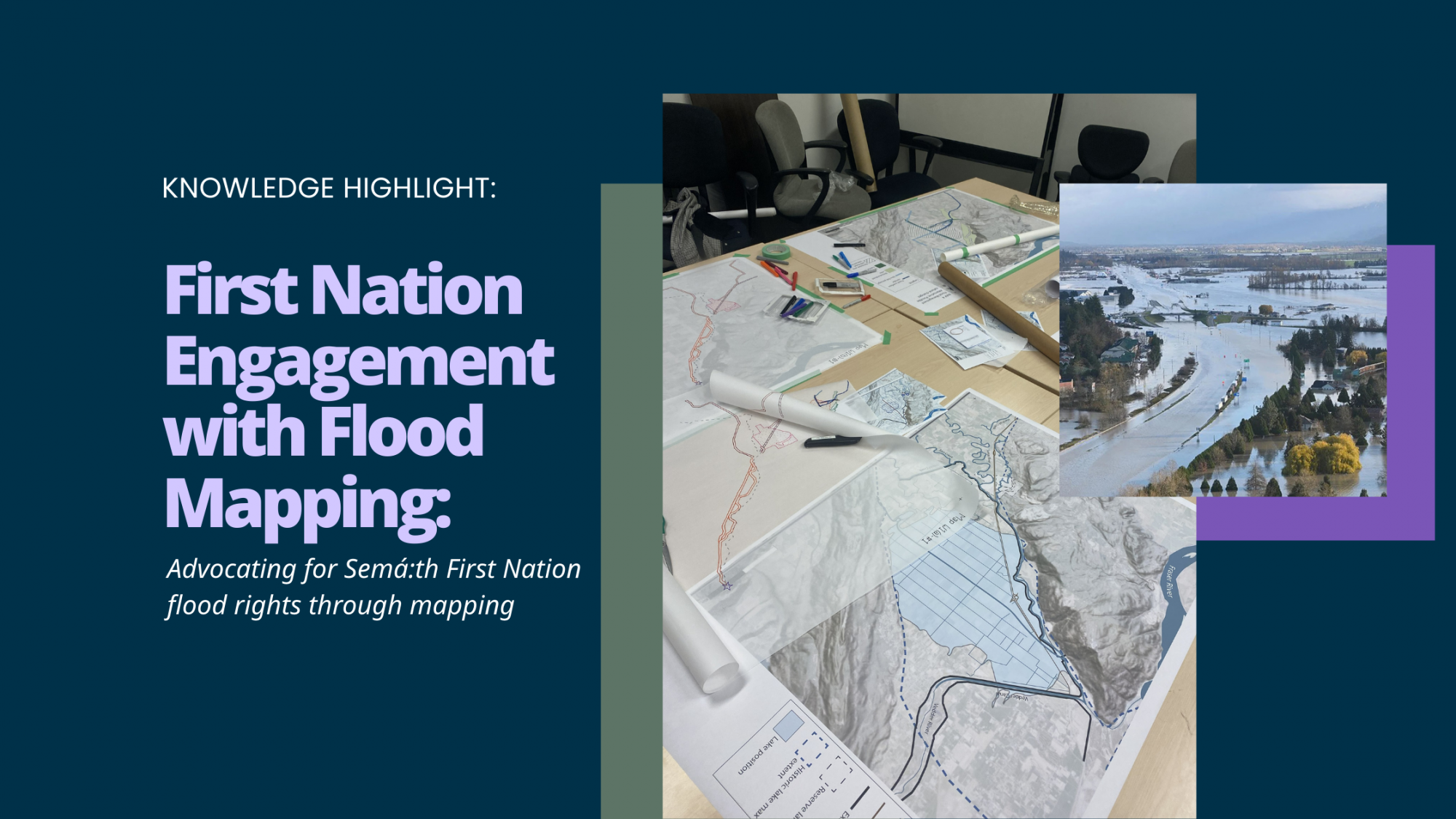
Our research looks to highlight creative methods for effective and culturally appropriate inclusion of First Nation perspectives in flood maps. In one part of the research, I work with Semá:th (Sumas) First Nation. We have explored a participatory mapping and ranking method that has helped represent the Nation’s interests in ongoing flood risk mapping, informing the flood management decisions being made in what is now known as the Abbotsford area following the 2021 B.C. floods.
Further, I am reviewing First Nation flood mapping engagement efforts from across Canada to create a framework that outlines the variety of ways that Nations can engage in (or lead) different stages of flood mapping, across different types of maps. The overall research goal of this work is to provide some clear engagement examples to the technical experts working on maps, and for the Nations seeking greater influence on mapping projects undertaken in their territories.
WHY THIS WORK MATTERS STO COMMUNITIES IN B.C.
While flood mapping is a positive and essential tool, it is important to ensure the maps will serve First Nation interests and won’t inadvertently accentuate past harmful settler-driven flood management practices. It is important that B.C. First Nations are given culturally sensitive opportunities to influence on-going flood mapping activities, if they want to.
Ko wai au?
Who am i?
I tipu ake au i raro i te maru o Maungawhau. Ko Tāngonge te wai. I grew up under the shelter of Maungawhau. Tāngonge is my water.
I am a PhD Candidate in the Institute for Resources, Environment and Sustainability at the University of British Columbia, and a Research Affiliate with Natural Resources Canada. I hold an MSc specializing in fluvial geomorphology and GIS and have worked as a researcher on Indigenous-partnered disaster risk projects in Canada and Aotearoa (“New Zealand”).
I hold whakapapa (ancestry) to the iwi (tribe) of Te Rarawa and am also of white European (Pākeha) descent. Te Rarawa’s territory once supported a large seasonal lake called Tāngonge before it was drained in the 1920s. The loss of this lake in the name of “flood management” mirrors similar losses experienced by some B.C. First Nations and is what drew me to research in Canada. I am passionate about the intersection of technical flood risk management and the opportunity for upholding and advocating for the rights of Indigenous peoples.

SOME IMPORTANT BACKGROUND
WHY ARE FLOOD MAPS IMPORTANT?
Floods cause an average of more than $1billion CAD of damage per year in Canada and the consequences of floods often disproportionately impact First Nations. To help guide flood risk-reducing actions we need to have visual estimations of where floods might go, how they might behave, and who or what might be damaged.
There are different kinds of flood maps, including:
- Flood hazard maps which show where flood waters will go and behave under different scenarios, and are the maps commonly used for making regulations.
- Flood vulnerability maps which show who and what is exposed to flood hazard.
- Flood risk maps which then take flood hazard and vulnerability information to make spatial estimates of where damage will occur. “Damage” can mean things such as loss of life, monetary loss, or impact to cultural wellbeing.
If flood maps are available, they can be used by governments, industries, communities, and individuals to support:
- Land use planning and regulation (what can be built where, and what activities are allowed)
- Design of flood infrastructure (construction of dikes, dams, vegetation restoration etc.)
- Emergency planning (where evacuations might occur and who should be prioritised)
- Flood insurance (who needs flood insurance, and who is allowed access to it)
- Informed property purchase (knowing whether a house is at risk of flooding)
- Funding requests (maps are sometimes used to help decide which communities are most in need of funding for future flood mapping projects or other flood risk reduction activities).
Flood maps provide the basis for many of the major flood management decisions that are made at different levels of Government. It is therefore important that the maps themselves can portray the interests of different communities, and that communities can effectively understand why they are created, and how to use them.
HOW ARE FIRST NATIONS ENGAGING WITH FLOOD MAPPING?
Many First Nations who experience flooding are undertaking their own flood mapping projects, led by the Nation and relying on external engineering contractors to lead analysis. Federal-level funding programs such as the First Nations Adapt Program and the Flood Hazard Identification and Mapping Program have been helping Nations fund their own flood mapping activities. These funding programs have led to an increase of on-reserve flood mapping across Canada, although they often lack wider resource support, and frequently see Nations competing against each other for limited funds.
Flood mapping projects that are led by Nations only make up a very small proportion of the wider flood mapping activities occurring across the country. The flood maps and resulting flood management decisions being made in wider watersheds are usually led by non-Indigenous governments. In the best cases, these governments are seeking out opportunities to engage with First Nations on mapping activities. The federal government has released its Indigenous Engagement Guidelines for Flood Mapping; while the guidelines offer a good foundation for the principles that are key to engagement, they offer limited practical examples for how to include First Nation perspectives in the maps themselves. Despite some amazing examples of how First Nations can be engaged with large-scale flood mapping projects, industry partners are overall left unsure of how to best include First Nation perspectives. At the same time, Nations are often unaware of the range of options they might have access to that could help them advocate for their rights and interests in the flood mapping process.
OUR ENGAGEMENT RESEARCH
RESEARCH GOALS
The goals of our research are:
- Provide an in-depth example on how to undertake effective engagement on flood (risk) mapping with a First Nation community (Semá:th First Nation).
- Support Semá:th First Nation in their advocacy for their interests in the flood management decisions being made in their traditional territory.
- Create a framework for how to undertake First Nations partnered flood mapping, drawing from case studies across Canada that offer a range of approaches that can occur at different flood mapping stages, for different flood mapping types.
Our intention is to generate research that will be useful learning for both the technical experts who are charged with creating most flood maps, and the First Nations communities who may be looking for ways to safely and effectively be involved in the flood mapping process.
OUR APPROACH
Participatory Mapping Project with Semá:th First Nation
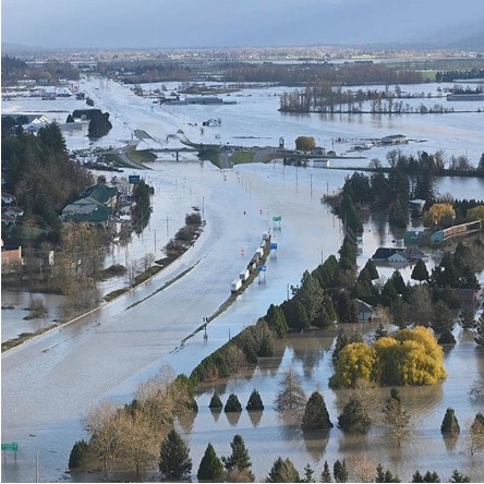
Semá:th (Sumas) First Nation’s territory was inundated during the 2021 B.C. floods. While the event was tragic, it opened up an opportunity for the Nation to advocate for their rights in the flood management occurring in their lands.
Over two years I co-designed a participatory mapping method with key Semá:th members and staff. We organized mapping and focus group workshops that allowed us to represent the environmental, cultural and spiritual values of Semá:th members, and to examine the potential impact (both positive and negative) of proposed flood management options in their territory. We needed a mixed-method approach that provided space for members to share their oral histories and wider context of each place of importance, and to also give numeric scores to the values being discussed for integration into wider risk mapping activities.
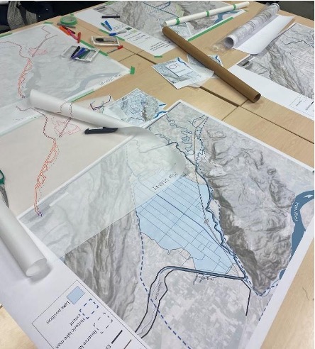
In November 2024 these workshops went ahead, and Nation members marked down and discussed areas of traditional and modern importance to them on maps of the wider “Abbotsford” area. We broke down the areas based on different values (environmental, cultural, spiritual) that had been previously co-developed by the Sumas River Watershed Flood Management Planning initiative, of which Semá:th is a partner.
Once participatory mapping of the different values was complete, we overlaid transparent maps of the major proposed flood management changes in the area. We could then see how proposed changes might intersect with areas of importance to the participants. We could then score the impact of different management options, along with the proposed increases or decreases in flood water amount in terms of whether it would harm or improve the wellbeing of each value. We adapted an Indigenous research method called the Mauri scale for this step, giving the likely lifeforce changes of each value numeric scores.
Semá:th (Sumas) First Nation
The Semá:th people are part of the larger Stό:lō Nation and have resided in and around the area now called Abbotsford since time immemorial. Semá:th Nation is deeply familiar and interconnected with the process of flood. There was once a large, flourishing lake in their territory, bearing the name Semá:th Xó:tsa. The lake (Xó:tsa) was heavily influenced by the seasons, and the Nation knew to treat the water with respect, to adapt their homes and activities to be in tune with the fluctuating water levels.
The Nation suffered a horrific loss in the 1920s when settlers drained the Xó:tsa, drastically changing the Semá:th people’s way of life. Since this drainage, the Xó:tsa has fought back, seeking to push through the engineered flood defences to return. The most recent return of the Xó:tsa happened in November 2021, when a large atmospheric river event saw widespread flooding and devastation throughout the lower mainland of B.C.

Following the 2021 floods Semá:th First Nation (and other local Nations) have partnered with local and B.C. governments to have a say in the flood management decisions being made, and our research was one step in this advocation process.
CASE STUDY ASSESSMENT OF FIRST NATION ENGAGEMENT WITH FLOOD MAPPING
There are several examples of First Nations leading and being engaged in flood mapping in Canada. Unfortunately, these projects are often not being publicly communicated. In terms of knowledge sharing and mobilization, it would be useful for there to be an assessed repository of appropriate engagement methods for Nations and technical experts to see.
At the time of writing this Knowledge Highlight, we have isolated 12 case studies for inclusion in our assessment. We specifically sought out case studies that cover a range of jurisdictions, flood mapping types, and engagement partners (government, academia, industry). Case studies were gathered through online searches and by reaching out for recommendations from academic, industry, and NGO partners. Key engagement information is now being extracted from the case studies, including details of the partners involved, the mapping stage at which the engagement occurred, and the methods used for engagement. Where possible, information on data governance and examples of the final mapping outputs are also being sourced. The final engagement framework will be reviewed by the First Nations Technical Working Group on Flood Mapping.
This work is ongoing, but we hope to share the findings both through regular publication, and an online story map that communities and mapping-experts can consult.
THE INITIAL IMPACT OF THIS WORK
The initial workshops with Semá:th First Nation have led to:
- Maps and data that outline the Nation’s current environmental, cultural, and spiritual wellbeing that can be used in wider flood risk assessment/mapping processes and flood management planning that is happening within their territory.
- A clear case study that highlights a co-designed, Indigenous-based method for how to undertake engagement to gather First Nation flood risk perceptions spatially.
- A report and hard copy maps that are being used by the Nation to advocate for flood management options that will both decrease their flood risk in the face of climate change and will help build the cultural and environmental wellbeing of their territory. These maps are also proving useful for other ongoing colonial claims being made by the Nation.
- The research has led to additional workshops a year later, providing space for knowledge-holders from other Stό:lō Nations (Leq’á:mel and Máthxwi) to also share their perspectives on the flood management changes occurring in their territories.
WHY THIS RESEARCH IS IMPORTANT IN B.C.
The creation and improvement of flood maps in B.C. will help everyone. The engagement of B.C. First Nations in any flood mapping in their territories will ensure that the maps capture their knowledge of the floods that have impacted them historically, along with information on what and where is important to protect or enhance in the future. This will then help ensure that flood maps can serve the needs of First Nation communities, just as well as they serve the needs of their non-Indigenous neighbours. Both the BC First Nations Climate Strategy and Action Plan and the BC First Nations Action Plan for Disaster Risk Reduction assert the need for greater capacity and leadership by B.C. First Nations in understanding and adapting to the impacts of climate change. With floods set to increase in frequency and severity due to climate change, it will only become more important to see opportunities created for B.C. First Nations to share what they know about the past behaviour of floods, and to have greater governance over the flood management decisions being made in their territories.
SOME TAKE HOME LESSONS
for FIRST NATIONS PARTNERED FLOOD MAPPING
From the work with Semá:th First Nation, and from speaking to other practitioners and researchers undertaking flood mapping in partnership (or under the leadership) of First Nations we can offer some pointers for those seeking to undertake culturally appropriate engagement. We would also direct interested readers to the Federal Government’s Indigenous Engagement Guidelines for Flood Mapping for a deeper summary of the principals and values that should underlay any collaboration.
- Build relationships and look for opportunities that will benefit the Nation first. Any researchers looking to engage with Nations on disaster topics should seek to formulate projects around the needs and requests of Nations who are seeking help and collaboration. Programs such as UBC’s Indigenous Research Support Initiative can be great places to begin relationships.
- Open up your worldview. Often Western scientists and practitioners view floods as only disasters, but in the eyes of First Nations it can be more complicated than that. Natural flood processes can bring life to rivers and shorelines. Be open in any methods used to the discussion and analysis of floods as a positive force.
- Listen with compassion. The topic of disaster, and past settler-driven risk management can be traumatic to some. Always give space for those involved to leave or to not answer questions.
- Communicate the potential flood management implications that flood maps can have. Always be clear that flood maps will help decrease flood risk but be open about the real-world impacts they can have.
- Acknowledge that mapping is steeped in colonialism. Historically maps have been used in the dispossession and destruction of Indigenous lands. Until very recently there has been limited inclusion of Indigenous peoples in flood mapping, and many communities will be rightly cautious to share information. Go slow and acknowledge these histories.
- Understand the importance of data governance. Related to the point above, if Nations chose to share any information in creating flood maps that they can use, it must be data that they can control, and they must have the final say over how any data is represented. Wherever possible, fully anonymize sensitive data, or keep it internal within the Nation only. When in doubt follow the OCAP principles for data governance.
- Never assume what counts as valuable. Often when working with First Nations it is tempting to assume that the protection of ‘traditional’ lands and practices from the impacts of climate change will be the priority. However, colonialism has had long-reaching impacts on many First Nations, and their modern priorities may at times be different. If collaborating with First Nations make sure your methods have space for their traditional and current perspectives, acknowledging that there may be overlap and divergence.
Charlotte Milne is a PhD candidate at the University of British Columbia, and a recipient of a PICS Uplifting Reciprocal Research Scholarship.

In honour of the Relationship Protocol between the Pacific Institute for Climate Solutions (PICS) and the First Nations Leadership Council (FNLC), this Knowledge Highlight series reflects PICS’ commitment to supporting the priorities of the BC First Nations Climate Strategy and Action Plan and the Action Plan for Disaster Risk Reduction by First Nations in BC through capacity building, research, and education.